
(Revised February 07, 2006
)
Introduction:
Shortly after Alabama became a state the new Governor and State Legislature commissioned the construction of the first state road. Byler and Associates were awarded the contract for the construction of a turnpike or toll road. The purpose of the new road was evident. It would connect the Tennessee River settlements to the Black Warrior waterway at Tuscaloosa. This would become a conduit into the wooded western frontier of Alabama. Many sources expound the importance of the Byler Road to this end.
Jacob Pickle and John Ray, both ancestors in my line, acquired land in Fayette County, Alabama in the mid 1820's to the early 1830's. Their land patents were taken on land that is situated physically close to the Byler. It is my contention that this turnpike offered the best migration route for my ancestors to have taken from their eastern homes.
Historical Development of the Byler Road
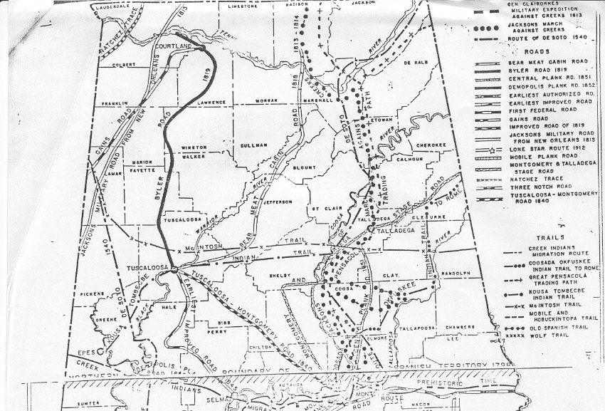
In November, William Wyatt Bibb had been inaugurated as Governor of the soon to been admitted to the union Territory of Alabama. Early that summer Bibb had defeated his opponent Marmaduke Williams by roughly two hundred votes for the position of the first Governor of the state. When Alabama was admitted to the union as the twenty-second state on December 14, 1819 one of the first concerns of Bibb and his new state government was the state of the roads in Alabama. On the sixteen of December Governor Bibb contracted John Byler to cut a toll road that would connect the Muscle Shoals region on the Tennessee River with Tuscaloosa on the Black Warrior River. Byler was contracted to build the road and was given certain rights that provided for the collection tolls for twenty years in lieu of maintenance cost. The year he died Byler sold a third of his interest in the road to a Jacob Byler of Lauderdale County, Alabama. Specification for the new turnpike allowed for a twelve foot wide road with the bed cleared of stumps and soft spots in the roadbed covered with logs. The tolls apparently were set by the state legislature. Rates included a toll of one cent per head of cattle, but only a half cent per head of sheep or swine. A man and horse had to pay twelve and one half cents, but a pack horse or mule was assessed six and one half cents. Wagons tolls varied from fifty cents to a dollar, based on the number of wheels present.
When the Byler Turnpike was cut Alabama was young and the county lines
of the day are much different than today. It is easier when examining the
path of the road to look at it in terms of modern county lines. The counties
may be different the communities, town, and wideplaces in the road are
more the less the same. All sources place the northern terminus of the
Byler Road somewhere in the vicinity of the Tennessee River near Muscle
Shoals. From the Shoals area in Colbert County the Byler Road extended
eastward to Courtland in Lawrence County. From Courtland the road passed
into present day Winston County via Moulton. It meandered along
the border of Winston and Marion and then across the extreme northwest
portion of Walker County. The road passed through Walker and into Fayette
County and from Fayette it extended into Tuscaloosa County finally ending
in the city of Tuscaloosa.
Alabama Highway Department Historic Road and Trails Map
(1975)
Sources:
ADAH Timeline www.archives.state.al.us/timeline
Baker, Ruth, A History Buff, He Carefully Recorded Data, Daily
Mountain Eagle Online Archives June 23, 2000.
Historic Roads and Trails Map State of Alabama Highway Department April 1975.
Location and Topographical Features of Winston County www.ala.nu/users/pjglocation.htm
Man Killed Chasing A Bear: Pioneer Jacob Pruit. Edward Herring, Bankhead Monitor, August/September 1992.
Pickett, Albert James ,History of Alabama, Chapter XLVII,
1851
Region Investigation of USFS In Alabama, Wild Alabama, May/June
1999